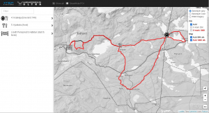
Nytt kart til bruk på datamaskin og mobile enheter. Når du zoomer inn i kartet vil et kartlag med avstandsmarkører automatisk bli vist (på zoomnivå 13 og over).
I tillegg kan du klikke på gps-knappen for å vise hvor du er i kartet.
Total elevasjon er 1330M+ for 34K og 4980M+ for 95K.

New map to be used on desktop and mobile solutions. When you zoom inn, distance markers will be shown automatically (at zoom 13 and above). Additionally you can activate the gps-feature in order to show your location on the map.
Here you can download GPX files for the 95 km and 34 km courses.
Total elevation is 1330M+ for the 34K and 4980M+ for the 95K.
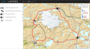


In case of bad weater or other reasons for the 95K not being safe to run, we have prepared
ALTERNATIVE courses: a 100km and a 35km course.
Total elevation is 1120M+ for the 35K and 2710M+ for the 100K.
You can click on the image below to go to the ALTERNATIVE map site.